R egardless of “Diamond John's” eventual reputation, John Wesley Huddleston of Pike County, Arkansas, had at least two outstanding qualities: a devotion to family and an unwavering faith in the value of land. Neither was unusual among men living in rural American during his lifetime. Neither would seem remarkable without the detrimental imagery of the folk tales looming in the background, especially the suggestion he was shiftless and irresponsible as a farmer. A reporter once came much closer to the truth when he wrote, after a long interview, “Land had always been a topic of thought with John, for he saw in it the source of all wealth.” [16]
In that respect, the son followed the example of his parents?David Fielding Huddleston and America White Huddleston?and other members of a large extended family. John's grandfather David Huddleston, the group's most prolific patriarch, had settled in Pike County in late 1835 as Arkansas Territory achieved statehood; and he soon became an outstanding leader of the community developing around the new county seat of Murfreesboro. Between 1840 and his death in October 1880, David Huddleston served as County Judge for eleven two-year terms. His two brothers, Lewis and William, also rose to prominence in the 1840s and ‘50s. Lewis occupied the Sheriff's office from 1843 until his death in March 1853. [17]
These three founders bought considerable land in Pike County before the Civil War. Initially settling east of Murfreesboro, David and William Huddleston eventually concentrated their holdings along the Little Missouri River a few miles southeast of town. David, the most enterprising of the three brothers, accumulated 307 acres by 1861. Lewis initially chose 102 acres just south of town by the junction of Prairie Creek and the river, immediately west of the future diamond discovery; then he and his wife, Mariah, bought a combined eighty acres of federal river-bottom land about two miles farther west. Shortly before John Wesley's birth, which evidently occurred in 1862, his father bought 150.82 federal acres along the bank of the river beside Lewis' second property. Lying in a wide floodplain of the untamed Little Missouri, the land in that area cost as little as 50¢ an acre, compared with the standard price of $1.25, and was suitable for crops and livestock. [18]
John Huddleston grew up with an unusually large number of relatives at hand. His grandfather David Huddleston produced at least twenty-one offspring, about half of them females. His great-uncle Lewis had only four children before his early death, while William apparently had none of his own; but David's descendants more than compensated for that deficit. John Wesley, himself, had seven siblings from his father's first marriage and three half-sisters from the second. After the Civil War, many in those second and third generations accumulated land along the Little Missouri?including several properties around the 243-acre tract where the diamonds eventually turned up. [19]
In early 1887, John Huddleston married Sarah A. Keys, an older woman with a three-year-old son from a previous marriage. [20] Two years later they bought a 49.26-acre home farm less than two miles southeast of the future diamond field. They also owned a scenic
14.5 acres between the south boundary of the 243-acre tract and the north bank of the Little Missouri, and had at least twenty acres about a half-mile eastward. They sold the small riverfront property in 1890 to help meet the needs of their growing family. In 1900, they sold the twenty acres after buying a more functional forty acres nearby from John's parents. [21]
Those modest transactions reflected the economic limitations of John and Sarah Huddleston at the turn of the century. While the couple had accumulated cattle, pigs, mules, and other assets, they never managed to save much cash for real-estate investment. In 1900, five daughters ranging from ten months to twelve years of age still lived at home, along with Sarah's sixteen-year-old son. Another daughter, their second-born, had died in 1895 at almost six years of age. [22] Although John was about thirty-eight years old and Sarah forty-four, they had managed to rise only to about the medium economic level of Pike County. [23]
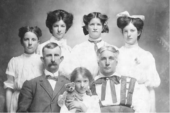
John and Sarah Huddleston and daughters after the discovery, c. 1908. Crater archive.
Nearby Murfreesboro, however, was the dynamic seat of county government, and that virtually assured steadily rising property values, especially after the homestead frontier began closing out in the late 1800s. [24] As their expenses rose at the turn of the century, John and Sarah Huddleston met them not only by farming and other work, but also by selling appreciating pieces of land or using the rising value of their farm to secure occasional loans from a patient, well-to-do landowner of the area. [25] Although parents and other relatives were there if needed, along with other kinds of support in the close-knit rural community, the couple essentially remained self-reliant and determined to make a better life for their family. That meant acquiring more and better farmland, raising more pigs and cattle, and accruing additional wealth through appreciation and the rental of excess land. [26]
[16] Shiras, “Diamond Discoverer,” p. 1.
[17] William, oldest of the three, evidently was installed as County Coroner for two terms, in 1852 and l862. For early acknowledgments, see the comment and lists of officeholders in Fay Hempstead, A Pictorial History of Arkansas, From Earliest Times to the Year 1890 (St. Louis: N. D. Thompson Publishing Company, 1890), 999-1001, and Goodspeed's Biographical and Historical Memoirs of Southern Arkansas (Chicago: Goodspeed Publishing Company, 1890), 307-308. Hempstead listed eleven terms for County Judge; Goodspeed mentioned ten, but omitted 1864-1866 (Goodspeed also included David Huddleston, erroneously, among those living in Pike County “prior to 1830”). The lists were reprinted in Pike County Heritage Club, Early History of Pike County, Arkansas (Murfreesboro, Arkansas: Pike County Archives and History Society, 1978), 20-21. Lewis' public service is also documented in the annual Sheriff's certification at the end of each county tax record (State Tax List, below, 1843-1852 [William Gilmer filled the vacancy after Huddleston's death and began signing as Sheriff on June 4, 1853]). The county sheriff served as tax collector and signed for the annual assessment at about mid-year, certifying he had received it from the county clerk.
In the available public records, David Huddleston was identified as “Judge” only once?on the census sheet filled out shortly before his death in October 1880. Previously, he always told the census-taker his occupation was “Farmer.” (Compare the census in 1840-1870 with 1880, Arkansas, Pike County, Thompson Township, p. 419, Dwelling/Family 79/79.)
[18] For land descriptions and other details about the Huddlestons, see the State Tax Lists, federal cash patents, genealogies, and other records reviewed below in Bibliographic Notes 2-3. The following summary reflects those sources, the federal censuses, and entries in the family Bible of patriarch David Huddleston.
Howard Millar's Finders-Keepers implied that John Wesley Huddleston descended from simple, struggling farmers; but the records fail to support that image. His grandfather David Huddleston, the son of Fielding Huddleston, was born in North Carolina in 1800 and evidently moved his young family to Pike County in the summer of 1835. John Wesley's father, David Fielding (D. F.) Huddleston, was about three years old when the family arrived. Soon afterward, they were joined by David's brothers, William and Lewis. (David Huddlestion's name appeared initially in the Pike County tax assessment for 1936 , which was completed by early summer of that year; he paid only a $1 poll tax, suggesting recent arrival. Adding further perspective, David's family Bible indicated his third son, Lewis A., was born in Arkansas September 27, 1835, and nothing suggests the family settled elsewhere in the state before reaching Pike County, a frontier of settlement [entries in the Bible, which recorded exact birth dates for 1800-1852, are online at http://www.pcahs.com/ , “Online Records Library”]. Moreover, the Sheriff-Collector's certification on the tax assessment for 1835, which did not list David Huddleston, was dated July 1835, which leaves about a two-month gap for Huddleston's arrival that year [deed and tax records below]. The census of 1840, a very limited questionnaire, recorded only the name of the head of household and the age distribution of other family members, along with David's identity as a farmer, his location in Missouri Township, and his status as non-slaveholder [original Census sheet, 1840, Pike County, Missouri Township, p. 69B]. Beginning in 1850, a more detailed census recorded that David Fielding was born in Alabama and Lewis A. in Arkansas.)
In 1850, seventeen-year-old David Fielding still lived at home with parents and siblings. The federal census of that year identified both him and his father as “farmer.” That same year, 1850, David Huddleston appeared on the Pike County tax assessment as owner of 196 acres of land by the Little Missouri River southeast of Murfreesboro, prime land he had purchased from private owners. He also filed for a patent on a small federal tract of 58.9 acres nearby, paying cash for it. In the Census of 1850, the enterprising patriarch was among the residents of Pike County who could declare they already had acquired property valued at $1,000. (Census, Missouri Township, household 231-231; annual tax assessments, below.) If grandson John Wesley was born in 1862, as the most reliable sources indicate, David Huddleston owned 307 acres by then and David Fielding had 150 of his own.
David Huddleston died in October 1880, at 79 years of age. According to the federal census that year, taken in June, he was living with his fourth wife, Mary, 40 years of age. Four minor children lived at home: Edda and Mary Huddleston, 18 and 16, listed as daughters, and the couple's daughter and son, Martha A. and Richard, 9 and 7. At the time, David and family lived close to his son “D. F.” ? David Fielding Huddleston. (Census 1880, Thompson Township, sheet No. 12, census p. 419B, Dwelling/Family 79/79; D. F. and family, Dwelling/Family 77/77.) Having outlived three wives, the old patriarch chose young Mary when he was over seventy years of age, and perhaps influenced John Wesley's even bolder venture several decades later.
The Huddlestons' earliest years in Pike County might seem to indicate the possibility of tenant farming, a subject Howard Millar referred to cryptically ( Finders-Keepers, 18: “Little was known about his family background, although he was the son of a sharecropper . . ..”). But the family's behavior in those pioneering years must be examined in full context, including David and Lewis' prominence as County Judge and Sheriff after late 1840.
At first, David Huddleston and other newcomers lived in one of the first three administrative divisions established in the county: Missouri Township, located immediately east of Thompson Township (in which the county seat, Murfreesboro, had been located in October 1834). The smaller Brewer Township lay at the southwest corner of Thompson. (Township map below, zoom in for details.) When David Huddleston arrived in 1835, Thompson and Brewer Townships had not been surveyed and officially opened to public entry under the federal Act of 1820; although Missouri Township had been opened, only six taxed landholders lived in all of Pike County at the time. After the federal survey began around Murfreesboro and the Little Missouri River, in 1837, the Huddlestons began buying expensive horses, cattle, and a few mules; but they apparently did as many other settlers and temporarily rented land in Missouri Township, although federal tracts were available for 50¢-$1.25 an acre and private, improved land for up to about $3. The Tax List showed no land after David's name when he began serving as County Judge in late 1840. Only after the more fertile river-bottom tracts of Thompson and Brewer opened for public entry in the early ‘40s did that pattern change. Lewis, youngest of the three brothers, finally bought 102 acres from a private owner in 1844, about two miles south of Murfreesboro. According to the official tax record, David bought his first land in Pike County from private owners in 1849 ? the 196 acres southeast of Murfreesboro. (State Tax Lists and federal patents, below).
Bibliographic Note 2 . Although fires destroyed the Pike County Courthouse in 1855 and 1895, the census records, annual Arkansas State tax records, federal and state land records, and available county records provide adequate details about the Huddleston family group and their migration and property ownership after 1835. For the basic genealogy , see Georgia Belle Huddleston Evans' thorough survey, “Fielding Huddleston of Parson Co., N. C., and His Descendants,” privately distributed (Nashville, Arkansas: 1990), 138 pp.; and Evans, compiler, “Huddleston Family Group Sheets,” originals in Pike County Archive and History Society (PCAHS), Murfreesboro and copy in Southwest Arkansas Regional Archives (SARA), Washington State Park, Washington, Arkansas (between the cities of Hope and Nashville, Arkansas). Also useful, but less reliable as well as less available: Patsy Ruth Mackey Stewart, “History of the Keys Family,” 2 vols. [1986], originals now in possession of Shirley Strawn, Murfreesboro. Information posted on the PCAHS website includes the entries in David Huddleston's family Bible, as well as a few related probate records and basic details from the federal census (above, Bibliographic Note 1a). Although many Huddleston genealogies are posted on the internet, very few of those relate directly to John Wesley's lineage, and the details are not always reliable. As a supplement to the census and Evans, the family entries in Cynthia Scott and Morris Meyers, “An Arkansas Connection,” are helpful: http://www.pcahs.com/pcaolr/database/acdpcd-p/i60.htm#268 . Whatever source is used, expect at least a few errors, especially in family sheets. Even Georgia Evans referred to John and Sarah Huddleston's youngest daughter, Joe M. (Joe May, or “Miss Joe”), as a male.
For initial orientation, also see the original Township Plats of Pike County (federal survey maps representing areas of approximately thirty-six square miles each ? the standard unit of federal land management). Except for land grants to States and Counties, each square-mile “section” (containing about 640 acres) was initially divided into quarters (160 acres), with major landmarks, early settlement, roads, and other features indicated. Townships were formally opened to public entry as surveys were completed in Territories or new States. To counteract speculative land monopolies and promote settlement by average Americans, quarter-sections were further divided into basic units of approximately forty acres (legally expressed as ¼ of ¼ of a section).
For the Huddlestons, the basic plats involved were those for Township 8 South of Base Line, Range 25 West of the 5 th Principal Meridian and Township 8 South, Range 26 West . Completed and approved in 1839, those two survey maps included the area around Murfreesboro and the Little Missouri River.
The original Township Plats and a map of survey base lines and meridians can now be viewed at the website of the federal Bureau of Land Management: http://www.glorecords.blm.gov/ . The BLM is gradually posting the related surveyors' field notes. The full set of federal land records is also available on CDs (plat maps; surveyor notes; and the original records of land patents and grants, known as “Tract Books”). A book of original Township Plats is available in the Circuit Clerk's Office, Pike County Courthouse, Murfreesboro, along with survey notes; and the PCAHS has a full set of CDs. Microfilm of the Plat Book for Pike County is also available at the Arkansas History Commission (FHL #1010612, Roll #13).
Territorial-State “Tax List .” Among early documents, the annual Territorial–State tax record for Pike County is the most informative. It began with the establishment of the county in 1834, and consisted of reports the county sheriff transmitted to auditors at the capital. Each report included a copy of the county tax-assessment ledger covering the previous year. Listing all white male adults in the counties alphabetically, that record soon began specifying not only their taxable real-estate, but also all other significant properties ? slaves, horses, cattle, pigs, saw mills, distilleries, and other items, including home furnishings and pocket watches. Poll-Tax payers were duly noted (white adult males only). Adding extra value for future researchers, the record sometimes identified the previous owner of land when a purchaser began paying taxes on it. From 1839 on, the “Tax List” submitted to the State almost mirrored the double-page ledger entries that the county used into the 1900s.
The preserved tax lists are in the archives of the Arkansas History Commission (AHC), Little Rock, and are partially available on microfilm: AHC, Pike County, Tax Records, roll 10 (copy also available at PCAHS). The roll covers 1834-1836 (Territory) and 1837-1867 (State). A second roll of microfilm, No. 11, is mislabeled and actually covers Pike County real-estate records for the late 1800s (described in note 9, below). Among various indexes of the Tax List, two volumes are outstanding, although of limited range: Ronald Vern Jackson and Gary Ronald Teeples, Arkansas Tax Lists, 1819-1829 and 18 30-1839 (Salt Lake City, Utah: Ambassador Press, 1978). Typed, abbreviated indexes for the early decades are available at PCAHS.
Although the ledger used for the early State Tax List had few page numbers, annual entries for the Pike County Huddlestons and other residents are easily located because of the alphabetical arrangement of names. The pattern of settlement in the early decades:
1834 . There were only 7 taxed landowners in Pike County, out of 100 taxpayers in all; officially, settlement was still limited to the southeastern part of the county.
1836. The ledger shows only the poll tax and total taxes of David Huddleston and other settlers; no descriptions of properties.
1837. David Huddleston 's personal property totaled $10 in value; no real-estate listed. “J. W.” Huddleston 's personal property totaled $80; no real-estate listed (l ater entered as “John W. ,” this Huddleston is not identified in available records; but the census of 1840 and 1850 has a young “ Wesley Huddleston,” with six slaves, living in the same area as David; moreover, in 1842 David named his newborn son “John Wesley”).
1839. A more detailed two-page ledger was used for the tax assessment, with real-estate description. Now, there were twenty-five taxed landowners in the county, many of them accumulating several tracts of land. David and “W.” (the first John Wesley) Huddleston were acquiring cattle only. Officially, settlement remained in Township 8, Ranges 23-24, and Township 9, Range 23, east and south-southeast of Murfreesboro).
1840. A few settlers had moved into Township 8, Range 25, around Murfreesboro; some individuals in Pike County owned as many as ten tracts of land. David and J. W. Huddleston were both acquiring horses as well as cattle, but no land although the best federal tracts cost only $1.25 an acre (David's two horses, valued at $90, and seven cattle, $93, placed him in the upper range of property valuations in Pike County).
1841. Settlement now was moving into Township 8, Ranges 26-27, west and southwest of Murfreesboro. The Huddlestons were still adding cattle (David, total property value of $155, with no slaves).
1842. Still, only David and “Jno. W.” Huddleston appeared in the tax assessment (David added two mules).
1843. Now the list included David, “John W.,” David L. (thirty-nine years of age in the census of 1850; born in Tennessee; had a young family), and “ Huddleston & Elliot .” Only H & L had land, sixty-two acres.
1844. Lewis Huddleston finally appeared as a taxpayer, although he was elected Pike County Sheriff in late 1842 and married Mariah Holliday about that time. W. L. Huddleston , young and born in Tennessee, had moved to the county (details in census of 1850). Both David and “D.L.” (David L.) still appear.
1845. David and Lewis were listed, with Lewis now taxed on 102 acres in Section 29, Township 8, Range 25, by the river south of Murfreesboro (bought from W. Ruder, valued at $300). Also listed: D. L., W. L., and “ D. C. K.” Huddleston , all born in Tennessee, all with young families, and all clustered southwest of Murfreesboro (Census, 1850).
1850. David now paid taxes on 196 acres in Section 34–8–25, by the river southeast of town (bought from private owners and valued at $600). William Huddleston, age 54, was living with Lewis and family, but did not appear yet on the tax list (Census, 1850, Brewer Township, Dwelling/Family 92-92). Six young Huddleston families were in the county at the time, including those of both “Wesley” and “John” (Census, Thompson and White townships).
1861. David owned 307 acres , including one federal patent for 58.91 acres (see “Federal cash patents” and “Veteran's Bounty Lands” below, for patents to William, Lewis, Mariah, and David F. Huddleston).
Federal Land Records . The BLM's website indexes the land patents granted in each Township, including names of recipients, dates, legal descriptions of tracts, and patent location numbers. Original patents can be view online, and copied for download. Certified copies of patents may be ordered online. Original township plats can be viewed online and fairly useful copies can be downloaded; but here online copying has limitations (unlike the low-resolution image appearing on computer screens, the Land Office's files are extremely high resolution).
As the BLM's “Frequently Asked Questions” points out, the patent certificates show only the date they were finally signed and issued, not the date an individual applied and paid the required cash or filing fee at a local land office . With applicants flooding the agency during the 1800s, settlers often waited well over a year for that large, impressive sheet of paper bearing a signature of the President of the United States of America. In any case, applicants usually secured their properties when filing and paying at a land office in their area.
For the details, see the original patent records, the Tract Books, Arkansas, Pike County (Washington, D. C.: Department of Interior, BLM). These double-page ledgers included all the basic information: description of the tract; total acreage; cost per acre; total paid; name of purchaser; date of sale; number of receipt; number of certificate of purchase; to whom patented; date of patent; and where it was recorded. Entries were updated into the 1900s in cases where later actions affected the original certificates. Although many entries are difficult to read, they are recorded by Range and Township, which facilitates research. The BLM provides two rolls of microfilm for Tract Books, Arkansas, Township South, Range West: Roll 1 covers Vols. 45-47 (beginning with the earliest Township-Ranges); the second, Vols. 48-50. The Huddlestons' band of settlement in Township 8 of Ranges 25 and 26 are in Vol. 48, pp. 127ff., and Vol. 49, pp. 85ff.
In addition to the BLM's website, there are various indexes to these records. Desmond Wells Allen and Bobbie Jones McLane, Index to Land Patents, Pike County, Granted Through 30 June 1908 (Conway, Arkansas: Arkansas Research, Inc, c. 1999) is the most detailed; David Kelley's online listing of patents includes basic information (PCAHS website: http://www.pcahs.com/ ). Using a more visual approach, Gregory A. Boyd, an ambitious professional in Norman, Oklahoma, recently began publishing a series of books based on the federal township plats and patent records (Boyd, Family Maps of Pike County, Arkansas , Deluxe Edition [Norman, Oklahoma: Arphax Publishing Co., 2006] applies in this case). Boyd mapped individual patent holders on blanks of the township plats and provided some of the basic information. Although he added separate maps indicating waterways and other outstanding features, the patent maps would have gained precision and meaning if streams, roads, and other landmarks had been shown there, as in the originals (e.g., compare these maps with the original Township Plats and the official patent descriptions for David Huddleston and David F. Huddleston, below). Nevertheless, Family Maps adds to the toolbox of genealogists and other researchers.
Settlers in the expanding American West received several kinds of federal patents. Beginning in 1820, tracts as small as about 40 acres were sold for a minimum of $1.25 per acre, cash. In 1862, the federal Homestead Act provided 160 acres to American citizens or citizens-to-be who paid a small filing fee, settled on the property for five years, and met guidelines for improvements. Following acts allowed even greater accumulation of timber lands and other non-agricultural acreage. Federal land grants to railroad companies ? a major spur to development in much of the West ? had very limited impact in Arkansas. Among other federal land policies were those allowing veterans to obtain patents as a bonus for service in wartime. For early generations of Arkansans, this involved Congressional Acts of 1850 and 1855 covering the War of 1812 and the Indian Wars that followed, particularly the Seminole War of 1818.
Federal cash patents gave some of the Huddlestons solid footing in Pike County before the Civil War. David Huddleston bought only one tract from the public domain, in August 1855 at 75¢ an acre, and he received the patent on that 58.91 acres the following year (the East ½ of the Fractional Southwest ¼ of Section 27, North side of the Little Missouri River, in Township 8 South, Range 25 West). The surveyed tract appears on the original Township Plat, which was approved for public entry four years after David Huddleston arrived in Pike County. Located about three miles southeast of Murfreesboro, the purchase no doubt influenced much of his extended family to establish home farms in that area instead of in the more flood-prone river plain upstream. (Tract Book, vol. 48, p. 133, David Huddleston; original patent certificate, BLM website.)
At first, however, other Huddleston patentees concentrated their farming either along that fertile river-bottom land beginning about three and one-half miles west of David's purchase or on higher ground a few miles beyond. William Huddleston and Mariah Huddleston (wife of Lewis) chose land just west of the river plain in January 1854, for $1.25 an acre, and received the cash patents in March 1855 (William, NE ¼ of the NE ¼ of Section 20, Township 8, Range 26, 40 acres; Mariah, SE ¼ of the SE ¼ of 20–8–26, 40 acres [both in Tract Book, Vol. 49, p. 89; website]). Other patents among the early arrivals: Lewis Huddleston , bought land January 17, 1859 for 75¢ an acre, patent received in 1860 (NE ¼ of SE ¼ of Section 26–8–26, 40 acres [Vol. 49, p. 90; website]); Lewis A. Huddleston [misspelled “Hudleston” on BLM site and patent cerificate , son of David, bought January 23, 1860 [no price indicated], received “Final Certificate” June 1, 1875 (SE ¼ of SW ¼ of 25-8-26, 40 acres [for all L. A. entries, see the Tract Book, Vol. 49, p. 90, and the BLM website; evidently he withdrew his previous application of August 1855, for 40 acres in SW ¼ of SW ¼ Section 25-8-26]); Louis A ., bought November 13, 1860, received patents May 1861 (two patents: NE ¼ of SW ¼ of Section 25–8–26, 40 acres at $1.25 each; NW fractional ¼ of SE ¼ of 25–8–26, 39.86 acres at 50¢ each); David Fielding Huddleston , son of David, received on May 10, 1861 (West side of the Little Missouri River, NE fractional 1/4 of Section 25–8–26, 150.82 acres at 50¢ each).
The bounty land acts of 1850 and 1855 affected many Arkansans, but very few Pike County Huddlestons. William, David Huddleston's older brother, served in the War of 1812 as a musician, and applied under both Acts. For some reason, he failed to get a patent ? perhaps because he was only about sixteen when the war began. (See Tract Books, vol. 49, p. 89, and the basic reference work, which has no entries for Pike County: Katheren Christensen, compiler, Arkansas Military Bounty Grants (War of 1812 ) [Hot Springs, Arkansas: Arkansas Ancestors, 1971]; also David Kelley, “Land Records–Pike County, Arkansas, Bounty Land Applications List 1851-1858,” and “Military Records,” both online at PCAHS website). Kelley's sources included Dorothy E. Payne, Arkansas Pensioners 1818-1900 (Greenville: Southern Historical Press, 1985), 68 (after William's death in July 1871, his surviving widow, Mary Corbell Huddleston, applied for his veteran's pension).
There were no bounty lands for Confederate veterans of the Civil War, which included David Fielding Huddleston and his younger brother John W. Both served 1862-1865. Later, however, they and their spouses could apply for the State of Arkansas' Confederate veterans and widows pension, enacted in April 1891 ($25 annually until raised to $100 annually in 1915). For this perspective, see the basic reference works: Frances Ingmire, Arkansas Confederate Veterans and Widows Pension Applications (St. Louis, Missouri: Ingmire Publications, 1985); Desmond Walls Allen, Arkansas Confederate Pension Applications from Clark, Garland, Hot Spring, Montgomery and Pike Counties (Conway, Arkansas: Arkansas Research, c. 1991). Extracts from state records are available at http://www.pcahs.com/ .
Swamp-Land Patents. Considerable federal land was transferred to territorial-state ownership over the years, much of it to promote public education. In 1850, an act of Congress allowed states to “reclaim” swamp lands and “overflowed” lands still in the public domain; many Arkansans received state patents under that program. The basic four-volume reference is Desmond Walls Allen, compiler, Arkansas Swamp Land Sales, 1855-1868; 1868-1879; 1879-1921; 1921-2001 (Conway, Arkansas: Arkansas Research, Inc., 2001). Allen's alphabetical lists of applicants include application numbers, patent numbers, location in State records, and the Section–Township–Range of properties. The original state land records are in the archives of the Arkansas History Commission, Little Rock. The AHC is gradually placing an index of the records online: http://www.ark-ives.com/documenting/land_records.asp . Copies of documents may be ordered online.
Among the Huddlestons of Pike County, none received a swamp-land patent until 1879 ( James D. Huddleston , following note).
Pike County Records, 1855-1890 . The burning of the courthouse in 1855 left no original deed records or county tax books to help document purchases of land up to that time; but some records escaped the fire of 1895. The Real Estate Assessment for 1883 and the Record of Tax Receipts for 1893 serve as clear reference points for land ownership those years (the two are described below, Bibliographic Note 3).
In addition , a private abstract firm had spent considerable time at the courthouse in 1890 copying a great many of the deed records and related court records and other legal documents produced after the first fire ? including many deeds re-filed after the courthouse burned the first time (property owners had the originals). Items were copied onto a regular, blank deed record ? the double-page format. After the fire of 1895, additional entries extended the abstract until about 1912, duplicating many deed records that are available at the courthouse today. Often referred to as the “Burned Records, 1855-1890,” the original of that 320-page “ Abstract of Title Book Prior to 1890” is still privately owned; but the Arkansas History Commission was allowed to microfilm it. The AHC did an excellent job with the old handwritten entries (only a few are too faded to read). Copies of the microfilm are available at the AHC (“Pike County Burned Records,” Roll #14), the PCAHS, and SARA.
A general index at the beginning of the Abstract indicates initial pages for deeds (arranged by range-township-section), Equity Court Proceedings, “Powers, Agreements, etc.,” Indefinite Instruments, Probate Court, Wills, Circuit Court, and Mining Claims. However, not all subject entries are neatly consolidated within consecutive pages: some categories are scattered, especially the latest deeds. At the end of pages, watch for a message indicating where the topic is continued (later pages will have “continued from page . . .”).
Generally, entries in the Abstract apply to the decades after the Civil War (see the next endnote). Entries for the earlier settlers are relatively few; yet they offer details lacking in the annual State Tax List, above (original records copied onto the Abstract usually included buyers and sellers, type of deed or other instrument, dates signed and filed, prices, and any special contract provisions). For entries applying to “Huddleston,” 1852-1865, see the following:
Abstract of Title Book, Deeds. David Huddleston , p. 107, line 10 (purchase from Sarah Blevin, widow of Hugh A. Blevin, in 1860; $45 for 49.6 acres, N. of River in N. ½ of SW ¼ of Section 27-8-25); Lewis Huddleston Estate , 105, line 1 (sale of two tracts of his land to Elijah Davis in 1852; $410 for partial E ½ of SE ¼ of Sec. 18-8-25); Lewis, Estate, 108, 3 (David Huddleston, Administrator; sale with mortgage to Rice Stringer in 1855 [paid off in 1858], SW ¼ of NW ¼ and Partial SW ¼ of Sec. 30-8-25; entry includes a brief history of the Swamp Act of 1850); Lewis, Estate , 108, 5 (Mariah Huddleston, widow, Adm.; sale of two tracts to Dickinson Duncan in 1855, $277 for Partial NE ¼ and NE ¼ of SE ¼ of Sec. 29-8-25); Mariah Huddleston Estate, 149, 13 (David Huddleston, Adm.; sale to Wilson D. Reed in 1858, $310 for SW ¼ of NE ¼, Partial SE ¼ of SE ¼, and NW ¼ of SE ¼ of Section 20–8–26, total 120 acres); William Huddleston , 149, 3 (sale to Wm. N. Preston in 1854, $117.62 for NE ¼ of NE ¼ of Sec. 20-8-26).
Probate Court Proceedings. Lewis Huddleston Estate , opposite p. 302 (double-page ledger), items 1.18ff. (L. H. died testate c. March 12, 1853; David H. appointed administrator April 23, 1855; inventory of holdings filed); Mariah Huddleston Estate , op. p. 302, items 1.162ff. (M. H., wife of Lewis, died testate in 1857; David H. appointed administrator; description of her three properties, sold in 1858 [tracts listed above with Deeds]; David Huddleston, Adm ., p. 305, B304 (Estate of Joel Clark, 1866).
Probate records usually included considerable detail about families and real-estate practices. After Mariah died, for instance, the administrator tried to rent out her property, but current economic conditions were unfavorable. The administrator obtained a court order to sell her 120 acres; Wilson D. Reed submitted the winning bid. For an exceptionally informative probate record, see following entries for David Huddleston's Estate.
[19] A thorough survey of family members involved in Pike County from the end of the Civil War (1865) into the 1900s can be compiled from a number of sources: the Federal Census (the survey in 1870 has limited value because of Civil-War dislocations; the records for 1890, Pike County, were accidentally destroyed before their release); Evans, “Fielding Huddleston and His Descendants” (a virtually exhaustive index of names, as well as a source of some personal data); federal land records (original Tract Books and BLM website); Pike County, Abstract of Title Book Prior to 1890, including the “Equity Court Proceedings,” pp. 290, 299 (David Huddleston's Estate, details about family members); Pike County Deed Records, 1895-; and tax records.
Bibliographic Note 3 . Tax records. As was the practice in those days, Pike County maintained detailed records of taxes due and taxes paid. Separate books were kept for personal property and for real estate. As noted previously, one annual tax record survived the burning of the courthouse in 1895: the Real Estate Assessment for 1883 , now stored in the Pike County Archives and History Society (PCAHS), Murfreesboro. In addition to that book, the Sheriff-Collector's Record of Tax Receipts for 1893 is in the PCAHS.
Basic tax records in the PCAHS include an annual three-part series extending from 1894 to 1913: Personal [Property] Assessment ; Personal Tax (“Taxes Extended [paid] Against Personal Property” ), and Record of Tax Receipts . Personal items are listed in both the Assessment and the Personal Tax books, but Personal Tax is more informative (it includes the date of payment and the page of the entry in the Record of Tax Receipts, as well as details about taxed items, the total tax valuation, total taxes paid, and a detailed breakdown of tax distribution ? school district, State, and County). The Record of Tax Receipts lists real-estate holdings, including rural tracts and lots-blocks in towns, but does not repeat personal property.
The Personal Tax record and the Record of Tax Receipts in PCAHS continue after 1913. The Personal Tax for 1923 and 1925-1929 were missing from the collection during this study.
The basic annual series covering real estate is in the records room of the Circuit Clerk's office, in the Courthouse: the Real Estate Tax Book, 1894–. In that ledger, rural tracts are entered first; town lots-blocks follow. Although the Tax Book has no index, rural tracts and owners are listed by Range, Township, and Section, which minimizes the researcher's work if a range number is known beforehand. Virtually all Pike County entries involved in this study are listed under Range 25, Township 8 (Range 25 West of Base Line, Township 8 South of the 5 th Principal Meridian) and Range 26, Township 8) .
These early records present a special challenge for researchers: well into the 1900s, men usually went by their initials, and public records reflected the practice. Sometimes it is difficult to distinguish between family members having different given names but the same initials. The Huddleston family group in Pike County, for instance, included two “J. W.” Huddlestons and two “W. Ds”: John Wesley ; Jasper Wooten. (John's cousin, the son of Woodson Jasper Huddleston); William Dudley (Bill) Huddleston (John's much younger cousin, the brother of Jasper W. and son of Woodson J.); and William D. (Bill) Huddleston (John's close cousin, the son of Louis A.). Fortunately, the two brothers ? W. D. and J. W. ? almost always acted jointly in buying or deeding property and paying taxes, which helps distinguish Jasper W. from John W. Literacy also helps separate the two: unlike John Wesley, Jasper signed his name instead of “making his mark” ? X ing documents (for instances, compare John W. Huddleston's X s in deeds cited throughout this study with Jasper's entries in Deed Record N, 352, Contract to Sell, W. J., W. D., and J. W. Huddleston, to Walter Mauney, August 14, 1907, and Mortgage Record 19, p. 317, J. W., W. D., and Etta Huddleston [wife of W. D.], to Pike County Bank, March 3, 1928). According to their marriage license, the older W. D. (Bill) Huddleston was thirty-five when he wed Mittie Steen, nineteen, on September 11, 1898 (Pike County, Marriage Record A, 205). The younger W. D. was forty-eight when he married Etta Watson, thirty, on July 28, 1923 (Marriage Record F, 470).
While male Huddlestons are relatively easy to trace through all these sources, married females require much more effort (Evans helps identify this extensive but less obvious part of the Huddleston network ? the Gentrys, Hutsons, Fugitts, Hoovers, Stuearts, Stewarts, Wagners, Rileys, and others). The following summarize only entries found for Huddleston, c. 1865-1900.
Federal Land Patents : James D. Huddleston , son of David, filed under the Homestead Act twice, in November 1878 and December 189_[5?], patents in 1884 and 1900 (W ½ of NE ¼ and NW ¼ of SE ¼ of Section 26-8-26, total 120 acres; Tract Book, Vol. 49, p. 90 and BLM website); Andrew J. Huddleston , son of David Fielding, filed for homestead in October 1899, patent in 1905 (SW ¼ of NW ¼ of Section 14–8–26 and SE ¼ of NE ¼ and NE ¼ of SE ¼ of Section 15–8–26, total 120 acres; Vol. 49, p. 88 and website); and Louis F. Huddleston , son of Lewis A., filed for homestead in February 1900 ($5 “purchase money”), patent in 1915 (SW ¼ of SW ¼ of Section 25–8–26, 40 acres; Vol. 49, p. 90 and website).
Swamp-Land Patents (State) . In Pike County, James D. Huddleston (son of David Fielding) received a patent in 1879 for 2.59 acres immediately across the river from his father's property in Township 8, Range 26 (Allen, Arkansas Swamp Land Sales, 53; and original Township Plat). The plat located the 2.59 acres at the northeast corner of Section 25, by the Little Missouri River (legal description: North of River, fractional NE ¼ of NE ¼ of Section 25-8-26).
The Pike County Real Estate Assessment for 1883 serves as a benchmark for the growing settlement south and southeast of Murfreesboro. This record and a few others were salvaged from the courthouse fire of 1895. Evidently, the county clerk also saved an unused real-estate assessment book left from 1880, and used that double-page ledger to re-record the Assessment and a few other damaged but salvageable items. On the first few pages of the main section ? the “List of Real Estate Assessed for Taxation” ? the clerk changed the printed 1880 to a handwritten 1883; other sections have updated entries ranging from 1880 to 1898 . The first section of the book covers rural real estate, 1883; the second, real estate in towns, 1883 (Murfreesboro only); the third, “16 th Section Notes” (op. p. 96 to op. p. 99; a record of debts owed in the 16 th section of the various Townships-Ranges, with payments or credits running to August 1892); the fourth, “Statement to Land Commissioner” (details about the 16 th Section and the School Fund, February 1886-March 1898); the fifth, a brief “Church Properties” (op. 125); the sixth, Pike County businesses and owners (op. 120-121). The original ledger and a microfilmed copy are in the PCAHS; microfilm is available at the AHC (County Records, Pike, Roll 11, labeled “1880-1894, 1893”). There are several entries for Huddleston :
D. Huddleston Estate , opposite p. 58, p. 59 (David's Estate more than two years after his death in October 1880); three properties in Sec. 27 and one in Sec. 34, Township 8, Range 25, total of 225 acres (North of River, E ½ and W ½ of SW ¼ of Sec. 27, 58.91 acres and 49.60 acres; South of River, fractional S part of SW ¼ of Sec. 27, 36.28 acres; N ½ of NW ¼ of Sec. 34, 80 acres).
W. J. Huddleston, 58, op. 59 (Woodson Jasper., one of David's youngest and most industrious sons; married to Margaret Keys), three properties in Sec. 28-8-25 and one in Sec. 33-8-25 adjacent to David's, total of 309 acres (W of River, fractional NW ¼ of Sec. 28, 29.50 acres; S of River, fractional SW ¼ of Sec. 28, 127.77 acres; S of River, fractional SE ¼ of Sec. 28, 72 acres; E ½ of NW ¼ of Sec. 33, 80 acres).
D. F. Huddleston , 58 (David Fielding, John Wesley's father and one of David's oldest sons), one property in Sec. 28-8-25 immediately across the Little Missouri River from W. J.'s (North of River, fractional SE ¼, 66.97 acres).
L. A. Huddleston , op. 79, 79, op. 81 (Lewis A., one of David's oldest sons), one property in Sec. 24-8-26, two in Sec. 25-8–26, and one in Sec. 36-8-26, total of 222.5 acres (E of River, fractional SE ¼ of Sec. 24, 66 acres; E ½ of SW ¼ of Sec. 25, 80 acres; fractional NW ¼ of SE ¼ of Sec. 25, 39 acres; NW ¼ of NW ¼ of Sec. 36, 37.50 acres).
Jas. D. Huddleston , op. 79 (son of David F.), one small property by L. A. in Sec. 25-8-26 (fractional NE ¼ of NE ¼, 2.59 acres).
The Abstract of Title Book allows a substantial overview of land ownership in Pike County from the end of the Civil War into the 1900s. The following are entries for Huddleston up to 1895:
Abstract, Deeds. W. J. and Margaret Huddleston , p. 107, line 31 (Woodson J. and wife, sale to L. A. Huddleston in 1885; $150 for 29.5 acres and 10 acres next to the river, west side, Sec. 28-8-25 (see the Plat, Township 8 S., Range 25 W); W. J. Huddleston , 107, 32 (purchase from Rebecca Dickson in 1873; $125 for fractional SE ¼ of Sec. 28-8-25, S of River [72 acres]); Woodson J ., 107, 54 (purchase from Chas. E. Welle and [M. A.] Holland, Commissioner in Partition, 1885; $150 for partial E ½ of SW ¼ of Sec. 27-8-25, 29.5 acres N of Spring Slew and next to the river); W. J. Huddleston , 107, 57 (Mortgage Deed, to M. A. Holland in 1887; $300 for fractional SW ¼ of Sec. 28-8-25, [127.77 acres]), W. J./“William J.” [should be Woodson J.*] and Margaret Huddleston , pp. 107 (lines 61, 71), 109 (75, 93), 158, 43 (Trust Deeds to Albert A. Shattuck and British-American Mortgage Co., Ltd. in 1888, 1890, 1901; $870.15 loan, lien initially on Partial SW ¼ of Sec. 28-8-25, south of river, and E ½ of NW ¼ of Sec. 33-8-25; gradual release of mortgage, with final discharge in 1901); Woodson J ., 109, 25 (purchase from B. and Elizabeth G. Davis in 1876; $275 [7?] for E ½ of NW ¼ of Sec. 33-8-25 [80 acres]); W. J Huddleston ., 109, 63 (Trust Deed to M. M. Mauney, Admin. of Estate of J. N. Conway, February 1885; $203.55 loan, for E ½ of NW ¼ of Sec. 33-8-25 [satisfied Feb. 1887]); W. J. Huddleston , 109, 69 (Mortgage Deed, to M. A. Holland in February 1887; $300 loan [satisfied in full March 1888], for E ½ of NW ¼ of Sec. 33-8-25); Margaret Huddleston , 109, lines 93 and 101 (from Estate of Wm. Keys, Deed to M. H., April 1889; $225 for NW ¼ of SW ¼ of Sec. 34-8-25, 40 acres [partition involved Hoover, Mitchell and other Keys, as well as Margaret Keys Huddleston).
David F. Huddleston , 107, 42 (David Fielding, purchase from John A. and A. L. Kelley in 1879; $220 for [North of River, fractional] SE ¼ of Sec. 28-8-25, 66 acres “more or less”); David F ., 151, 29 (sale with lien, to Thomas S. Neall in 1872; $165 for [fractional] NE ¼ of Sec. 25-8-26); David F. and Francis Huddleston, 151, 31 (sale with lien, to William F. Cary in 1879 [lien paid in full 1881]; $400 for Fractional NE ¼ of Sec. 25-8-26).
L. A. Huddleston , 107, 52 (Lewis A., purchase from N. B. Thomasson, Commissioner for estate sale in 1884 [David Huddleston Estate, below]; $150 for Fractional NE ¼ of Sec. 25-8-25; L. A. and Jane Huddleston , 107, 69 (sale to S. W. and S. E. Bryant in 1890; $360 for Partial NW ¼ of Sec. 28-8-25 [the two properties bought from W. J. and Margaret in 1885, above]); Lewis A , 148, 74 (purchase with mortgage, from Laura Evans in 1881 [paid in full 1883]; $115.40 for Fractional SW[?] ¼ of SE ¼ of Sec. 13-8-26).
J. W and S. A. Huddleston, 107, 63 (John W. and Sarah A., sale to J. A. Wolff in 1890; $187.02 for Partial NE ¼ of SW ¼ of Sec. 28-8-25, N side of river, 14.5 acres, [see Plat]); J. W. Huddleston , 109, line 117 (purchase from H. J. and A. C. Thomasson, Dec. 1889; $100 for Fractional SE ¼ of Sec. 34-8-25, S side of River, 49.26 acres).
James D. Huddleston, 108, line 101 (purchase from Peter and Mary Gosnell in 1884; $100 for Partial NW ¼ of NW ¼ of Sec. 30-8-25, “all that part lying West of Sandy Slough, 10 a. in NW corner of the 40”).
Lewis Huddleston , 153, 27 (purchase from Louisa Tuttle in 1871; $70 for Fractional N_[?] ¼ of NW ¼ of Sec. 36-8-26, 37.5 acres.
*The given names of Woodson Jasper Huddleson and family evidently created a bit of confusion in those days. Eventually, Woodson was known as “Jasper” and his son Jasper as “Woot.” Their gravestones bore those simple inscriptions (Japany Cemetery, southeast of Murfreesboro).
Abstract, Equity Court Proceedings . W. J. Huddleston , op. p. 285, April 1884 term, entry B214 (W. J. was plaintiff in a suit over a loan of $150 to Booker D. Brock in January 1881, with Brock's land as collateral; court awarded W. J. $150 plus $48.78 interest and ordered the land sold to satisfy that amount; Commissioner W. B. Thomasson executed public sale to C. M. Reid for $200); W. J. and Margaret Keys Huddleston , op. p. 285, July 1987 term, B290 (“Petition for Partition” of lands in the Keys Estate; lands were sold and the money was divided among heirs).
David Huddleston Estate , p. 299: April 1884 term, B199 and B212 (related to entry below under “Powers, Agreements”; provided further information about the October 1884 term, B220, and April 1885 term, B241). Repeated the decision to sell the properties, with W. J. Huddleston the administrator. Stated that David had twelve children involved, and listed them. Gave additional family history, including names of the deceased and their heirs. Described lands in Sec. 27 and 34 of Township 8 S, Range 25 W, and the sale to L. A. Huddleston [below]. Described another sale under the October 1884 term: N. B. Thomasson paid $430 for fractional S ½ of SW ¼ of Sec. 27-8-25, S of River, 36.25 acres, and “NW Sec. 34” [NW ¼ of 34-8-25; cf entry under Assessment of 1883, above ? N ½ of NW ¼ of Sec. 34, 80 acres]. Noted that in the April 1885 term, L. A. Huddleston's deed was assigned to Woodson J . (directly from the estate); no price indicated.
Abstract, “Powers, Agreements, etc.” David Huddleston Estate , p. 290, October 1884 term, entry J394. Court approved partition of property and then approved sale if an equitable division not possible; properties sold June 14, 1884, and deeds completed April 15, 1885. This long, detailed entry covered the legal process, in which Woodson J. Huddleston was both a party and the administrator of the estate, as well as the guardian of Martha A. Huddleston, et al. Also involved: L. A., David F., “John,” “J. W.”, and _[?]. J. Huddleston, along with Catherine Gentry, Adaline Bryant, Elizabeth Brown, and others. L. A. Huddleston [appears to be L. W.] paid $150 for 58.91 acres in E ½ of SW ¼ and 49.6 acres in W ½ of SW ¼, both in Sec. 27-8-25, N of River.
Abstract, Indefinite Instruments . L. J. Huddleston , p. 300, entry D109. Purchase from Jas. W[?] Holland and R. J. Holland October 17, 1874: $100 for fractional SE ¼ of Sec. 24-8-26, W of River.
Pike County Deed Records, 1895-, refilings after the last fire. Record W, page 615, L. A. Huddleston and J. D. Huddleston , Agreement setting property boundary between the two, November 8, 1886 (their lands “between the Sandy Creek and Little Missouri River”); Record B, 95, Warranty Deed, L. A. and Jane Huddleston to S. W. and W. C. Bryant, November 24, 1890 ($360 for Fractional NW ¼ of Sec. 28-8-25, next to River, 29.5 acres, and all the land lying down Spring Slough to the River, 10 acres [property across the Little Missouri southeast of the future diamond field, shown on original Tract map of Township 8 S, Range 25 W]); Record 31, p. 71, Warranty Deed, D. F. and Francis Huddleston to Lee J. Wagner [husband of their daughter Harriett; brother-in-law of John Wesley], November 29, 1894 ($20 cash for partial NW ¼ of NW ¼ of Sec. 27-8-25, 10 acres: “begin at the SW corner of NW ¼ of NW ¼, run “east ½ quarter mile thence north ½ quarter of a mile thence west ½ quarter of a mile to the section line, thence south” to the beginning corner).
In the records, Harriett Wagner sometimes appeared as Harriette or Harriet. In legal papers, it was usually “ H. D.”, but once appeared as Harriet: Deed Record 57, p. 508, WD, L. J. and Harriet Wagner to Ivie Keys, December 17, 1940; Lots 7-12, Block 3 of Goodlett Addition, Murfreesboro, part of the NE ¼ of the SW ¼ of Section 17-8-25. The obituaries of John Huddleston misspelled her name “Harritt” (obituaries cited below). Evans, “Fielding Huddleston and Descendants,” used “Hariett” (51).
Pike, Record of Tax Receipts 1893 (kept by the Sheriff/Collector; no index; receipts arranged in numerical order). L. A. Huddleston , opposite p. 46, six tracts of land (E of River, fractional SE ¼ of Sec. 24-8-26, 66.71 acres; E ½ of 25-8-26, 80 acres; NW ¼ of SE ¼ of 25-8-26, 39.6 acres; fractional NW ¼ of NW ¼ of 36-8-26, 40 acres; SE ¼ of NW ¼ of 19-8-25, 40 acres; W ½ of SE ¼ of 19-8-25, 80 acres); L. F. Huddleston , op. p. 77 (no taxed land; $344 personal property); W. D. Huddleston , p. 65 (W of River, fractional NE ¼ of 25-8-26, 150.82 acres); J. D. Huddleston , p. 78 (E of River, NE ¼ of NE ¼ of 25-8-26, 2.59 acres); W. J. Huddleston , op. 81 (no taxed land; $355 personal property); J. W. Huddleston (Jasper W.) , op. 83 (no land; $40 personal); W. D. Huddleston , op. 83 (no land; $60 personal); J. W. Huddleston (John W.) , op. 85 (W of River, Fractional SE ¼ of 34-8-25, 49.26 acres); A. J.(?) Huddleston , op. 85 ($43 personal); D. F. Huddleston , p. 85 (W ½ of NW ¼ of 27-8-25, 80 acres; W of River, SE ¼ of 28-8-25, 66.27 acres); J. R. Huddleston (no land; no personal tax; $1 total taxes [poll tax?]).
[20] U. S. Census, 1900, Pike County, Arkansas, Thompson Township, p. 93B, Household/Family 61/61 (John W., age “40,” and Sarah A., 46; married 13 years; oldest daughter, Mary A. E., born November 1887); Pike County, Arkansas, “Reconstructed Marriages 1834-1895,” an alphabetical listing of information accumulated since the early 1990s, online at http://www.pcahs.com/ (John Wesley Huddleston and Sarah A. Keys, married 1887). Family genealogists have accepted 1887 (e.g, Evans, “Fielding Huddleston and His Descendants”).
[21] Deed Record B, 582 , Warranty Deed, H. J. Thomasson to J. W. Huddleston, December 21, 1889 ($100 cash for 49.26 acres; south side of the Little Missouri River, fractional SE ¼ of Section 34, Township 8 S of Base Line, Range 25 W of 5 th Principal Meridian); Abstract of Title Book Prior to 1890 , Trust Deed, J. W. and S. A. Huddleston to J. A. Wolff, March 17, 1890 ($187.02 for partial NE ¼ of SW ¼, north of River [14.5 acres], Section 28-8-25); Deed Record 31, p. 66 , Warranty Deed, J. W. and S. A. Huddleston to S. L. Smedley, November 19, 1900 ($30 cash and lien note for $30 at 10%, 20 acres, N ½ of NW ¼ of NW ¼, Section 27; deed filed April 14, 1915); Record 38, p. 121 , Warranty Deed, D. F. and Francis Huddleston to J. W. Huddleston, May 16, 1900 ($150 cash for 40 acres; SW ¼ of W ½ of NW ¼, Section 27; property description corrected later in Record P, 136, Quit Claim Deed, D. F. and Francis to J. W. Huddleston, November 6, 1907, for SW ¼ of NW ¼, Section 27). The original Township Plat, 8-25, defined the 14.5 acres on the river.
[22] US Census, 1900, Pike County, Arkansas, Thompson Township, p. 93B: John W. Huddleston, age “40,” married 13 years; Sarah A., born “Oct 1853,” 46; Mary A. E., born Nov. 1887, 12; Delia E., Aug. 1890, 9; Eunice F. V., Sept. 1892, 7; Willie M., daughter, Aug. 1895, 4; Joe M., daughter (Joe May; later called “Miss Joe”), July 1899, 10 mos.; John T. Keys, stepson (son of Sarah), July 1883, 16. The details of Sarah's first marriage remain unclear.
Although the Huddlestons of Pike County preferred to use plain native-rock markers instead of regular headstones, John and Sarah Huddleston evidently felt the grave of their second-born warranted a small white-granite tablet inscribed “ELLEN D. Daughter of J. W. and S. A. Huddleston Born April 11, 1889 Died March 20, 1895.” The original Huddleston family burial site, called Japany Cemetery, is about four miles southeast of Murfreesboro beside Highway 301 (further comment and photographs below).
For details about livestock and other “personal property,” see the annual Personal Tax Assessment, PCAHS. Pike County tax records, 1894-, are described above, Bibliographic Note 3.
[23] Personal Tax Record for 1900, p. 43, original records in Pike County Archive and History Society, Murfreesboro; census records (above).
John and Sarah Huddleston's taxable personal property in 1900: 5 cattle, total value of $40;, 2 mules, total of $60; 23 hogs, total $25;, 1 carriage or wagon, value not indicated; 1 gold or silver watch (the listed value, $3, fell under a category including watches and “Diamonds and Jewelry of every kind”); additional taxable personal property (unspecified), $50; total value as equalized (total of valuations), $178; and total taxes, $2.74. This placed the family slightly above the average of the area (e.g., the forty-one taxpayers on page 43 averaged $168.50 total valuation).
[24] A popular study of Pike County published before the turn of the century stated the point concisely: The assessed value of county property, both real and personal, was, in 1889, $756,177. In 1874 the total assessment was $342,379; an increase, it will be seen, in fifteen years, of $422,798. This healthy growth is simply the increased value of farm property, and may be counted on to increase, in even a more rapid proportion, in the future, as much land is being reduced to a state of cultivation by both the native citizens and immigrants, and of the home seekers in Arkansas, Pike County is receiving quite a liberal share. (“Pike County–Financial Showing,” in Biographical and Historical Memoirs of Southern Arkansas [Chicago: The Goodspeed Publ. Co., 1890], section available online at PCAHS, Online Records Library: http://www.pcahs.com/ .)
[25] The records show only three secured loans for the Huddlestons before the discovery of diamonds in 1906, and those occurred at the turn of the century when they were raising five daughters and buying more land. Their 49.26-acre farm, bought in late 1889 for $100, served as collateral (deed above). The lender, Owen B. Owens, evidently knew the Huddlestons well, and allowed extensions of notes at a high interest rate: Pike County Deed Record B, 221 , Mortgage Deed, J. W. and Sarah A. Huddleston to Owen B. Owens, November 12, 1896 ($100 loan, at 10% interest if not paid by November 1, 1897 [marginal notation: paid in full May 16, 1900]); D, 63 , Mortgage Deed with Power of Sale, Huddlestons to Owens, May 16, 1900 ($265 loan at 10%, due November 15, 1900 [paid in full February 26, 1915 (sic.)]); G, 51 , Mortgage Deed, Huddlestons to Owens, August 2, 1902 ($390 loan at 10%, due by December 1, 1902 [paid in full August 17, 1907]). Such mortgaging became a widespread practice after the Civil War and the settling of the homestead frontier, especially as farmers began using planted crops as collateral for loans in order to meet expenses before the harvest. As the study in 1890 said, both that crop-financing system and the general mortgaging of property declined steadily as the agricultural resources of Pike County brought more independence to farmers (“Financial Showing,” above). Yet, wealthy individuals in the Murfreesboro area remained a source of loans well into the 1900s (e.g., J. C. Pinnix and John Huddleston in the mid 1920s, discussed later).
Between 1890 and 1900, the Huddlestons sold only one small piece of property: Deed Record 31, p. 66, Warranty Deed, J. W. and Sarah A. Huddleston to S. L. Smedley, November 19, 1900, deed filed April 14, 1915 (20 acres for $30 cash and $30 lien note at 10%, for North ½ of NW ¼ of the NW ¼ of Section 27, Township 8 South, Range 25 West). About two years later, they sold 4.4 acres of the 49.26-acre farm for $60: Record K, 21, Warranty Deed, Huddlestons to J. R. Fagan, et al., October 4, 1902 ($30 cash and $30 due by January 1, 1903). After the discovery of diamonds and their move to nearby Clark County, they sold the remainder of the farm for $2,300: Record 29, p. 629, Warranty Deed, Huddlestons to W. D. Fagan, et al., August 22, 1911 ($500 cash down and balance in annual payments until January 1, 1915, at 8% [marginal note: paid in full February 19, 1917], for 44.85 acres in SE ¼ of Sec. 34-8-25, west of River).
[26] Lacking the promissory notes relating to deeds, there is no way to determine if David Fielding Huddleston backed his son directly. In any case, David F. and his brothers had land at their disposal, available to sell or transfer in case of any financial emergency, and they were a cohesive group. Approaching old age, the elders had already started deeding properties to their offspring and other relatives. John Huddleston's sister Harriett D. and her husband, Lee J. Wagner, for example, had gotten small tracts from family members, all by the future diamond field: Record 31, p. 71 , Warranty Deed, D. F. and Francis Huddleston to Lee J. Wagner, November 29, 1894, deed filed April 14, 1915 ($20 cash for ten acres in Section 27: begin at the SW corner of NW ¼ of NW ¼, run east ½ quarter mile, then north ½ quarter mile, then west ½ quarter mile to the section line, then south down to the point of beginning); Record 28, p. 515 , Warranty Deed, D. F. and Francis Huddleston to Lee J. Wagner, March 14, 1898, deed filed April 14, 1915 ($10 cash for ten acres: SE ¼ of NW ¼ of NW ¼, Section 27); Record N, p. 408 , Warranty Deed, L. J. Huddleston [Lewis Jackson, brother of Harriet D. and John Wesley] and wife, R. L., to Lee J. Wagner, November 17, 1902 ($225 for ten acres in SW ¼ of NE ¼, Section 28, as described further in the deed). Deed records show this became a broad pattern within the Huddleston clan around the turn of the century, just as it did within many other family groups. Some properties went first to widows and later to offspring. Sometimes, family estates were kept intact and sold at public auction after the death of an individual or a surviving spouse, with proceeds divided between heirs.
As other ambitious farmers of those days, John Huddleston "knew the rental value of good farm lands,” and looked forward to becoming a landlord (quotation from his later statement, in Shiras, “Diamond Discoverer”).